Info
District: Tulkarm
Occupation date: 01/04/1948
Occupying unit: Hagana units
Jewish settlements on village/town land before 1948: Beit Yehoshu'a
Jewish settlements on village/town land after 1948: Hadasim (Education Institute), Netanya South Neighborhoods (Kiryat Nordao), Givat Hairusim, Neot Golda, Neot Menahem Begin, Ramat Yadin, Neot Shaked, Neve Oz, Netanya South Industry Area
Background:
Ghabat Kafr Sur Before 1948:
The village stood on level terrain on the coastal plain, south of Khirbat Bayt Lid and Bayyarat Hannun. Coastal sands crept deep into the middle and south sections of the village and formed rugged sand dunes. Secondary roads linked the village to the main Jaff-Haifa highway.
Originally the village was located within the large Arsuf forest, however the villagers cleared the land of the trees in order to cultivate it.
Wells and springs were abundant in the northern and eastern parts of the forest. The villagers were mostly Muslim and planted orange trees, as well as grew grain, watermelons and pistachios.
Occupation and Depopulation:
The circumstances of the occupation of Ghabat Kafr Sur are unclear. In April and the first half of May many communities in this area were attacked and/or expelled or fled in fear. The Haganah General Staff came to a decision to “secure” the entire coastal area between Tel Aviv and the settlement of Zikhron Ya’aqov by driving out all Arab inhabitants before 15 May 1948. Israeli historian Benny Morris writes that villagers f nearby by Khirbat Bayt Lid fled out of “fear and isolation” on 5 April.
Israeli Settlements on Village Lands:
Zionists established Beyt Yahoshu’a and Tel Yitzchaq in 1938, on lands that had been purchased by the Jewish National Fund but had traditionally belonged to the village. Kefar Netter was built one year later, about 2 km north of Beyt Yahoshu’a.
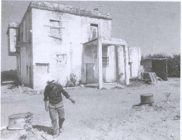
The Village Today:
A considerable portion of the site consists of sand dunes overgrown with wild vegetation. Several large eucalyptus trees also grow on the site.
The remains of three large Arab houses are visible in the midst of newly planted orange groves in the east and northeastern parts of the site. They are used by Israelis as agricultural warehouses.
-------------------
Source: al-Khalidi, Walid (ed.). All that remains: the Palestinian villages occupied and depopulated by Israel in 1948. Washington DC: 1992.
Images