Info
District: Tulkarm
Population 1948: 20
Occupation date: 1948
Occupying unit: Hagana units
Jewish settlements on village/town land before 1948: None
Jewish settlements on village/town land after 1948: None
Background:
Fardisya Before 1948:
The village stood on the northwestern slope of a hill on the coastal plain, just north of the town of al-Tayyiba. Secondary roads linked the village to al-Tayyiba and the Tulkarm-Qalqilya highway, which ran west of the village. The village was identified with the Crusader site known as Phardesi. In 1596 Phardesi was a village in the nahiya of Bani Sa’b (liwa’ of Nablus) with a population of eighty-three. It paid taxes on a number of crops, including wheat, barley, and olives, as well as other types of produce, such as goats and beehives. In the late nineteenth century Fardisya was a small village near the edge of a group of hills.
The houses were arranged in a triangular fashion along the western and southern borders of the village. A mosque named after a religious teacher, Shaykh Musa, was located on the western outskirts of the village. To the north lay a spring, which in combination with village wells provided the community with drinking water.
Occupation and Depopulation:
The villages throughout this section of the coast came under increasing pressure in April and early May 1948 from Haganah and Irgun attacks and expulsion orders. Although the exact events of what took place are not known it is likely that the villagers were displaced during early April. By mid-May the Haganah had fulfilled its aim of “clearing” all Arab inhabitants from the coastal plain between Tel Aviv and Zikhron Ya’aqov, a settlement south of Haifa.
Israeli Settlements on Village Lands:
There are no Israeli settlements on village land. Sha’ar Efrayim, built in 1953 to the north of the site, is close to the village of Fardisya.
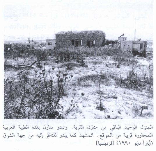
The Village Today:
With one exception, all the houses have been levelled, and rubble is scattered throughout the site.
The sole surviving house is rectangular with an eastern arched entrance and arched windows. On the western side of the village lies a tomb with a headstone bearing a Qur’anic inscription.
The remains of the village cemetery can also be seen to the northwest.
----------------
Source: al-Khalidi, Walid (ed.). All that remains: the Palestinian villages occupied and depopulated by Israel in 1948. Washington DC: 1992.
Images