Excerpts from the booklet:
Introduction
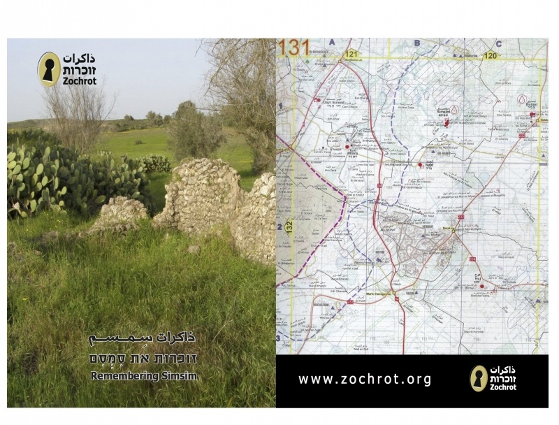
This booklet, published in connection with the tour planned to the ruins of Simsim, represents an attempt to document the obliterated history of this Palestinian village and the social, cultural and economic lives of its 1500 inhabitants. On 13 May 1948, the Palmach's Negev Brigade severed the threads of village life and the dreams of its residents. The Zionist forces expelled them toward Gaza. Most of the village's refugees still live in the Jabalya refugee camp, some 15 kilometers from their village, forbidden to return or even to visit. Only two families live in Israel today, and only they, among the thousands of Simsim's refugees, are able to reach the remains of their village and reconnect with their roots, if only for a few hours. Kibbutz Gvar'am, established near Simsim in 1942, was the jumping-off point for the Israeli attack in 1948. Later, the kibbutz "benefited from" the village's lands. Today, the center of the village, including the remains of some 345 houses, a desecrated cemetery, dry wells and a ruined mosque, is fenced off as the "Gvar'am Nature Preserve," and for the use of the kibbutz cattle.
From the time they were expelled until now, Simsim's refugees, like the hundreds of thousands of other refugees in the Gaza Strip, have suffered not only from harsh living conditions, but also from additional violent Israeli attacks, including being captured again in 1967, bombing, shelling and assassinations. The brutal Israeli attack at the end of last December and the beginning of January was one more violent chapter in the Palestinian Nakba that began in 1948.
The Qassam rockets fired from Gaza by the Palestinians reach the villages and the lands from which they were expelled in 1948. The Qassams are fired at the roots. The roots of the conflict. Instead of understanding that the Israeli-Palestinian conflict can only be solved by recognizing the Palestinian refugees' right to return, and instead of taking steps to bring about this return, the Israeli response was to wage another cruel war. The Israeli army caused very many casualties, primarily among civilians, including women and children, sowed great destruction, but, of course, failed to solve the problem.
Zochrot calls on Israel to accept responsibility for the Nakba and suffering that it caused, and which Zionism continues to cause the Palestinian nation, and calls for returning the Palestinian refugees to their lands as the basis for a solution to the conflict between the peoples of the region.
Clearly, choosing a Palestinian village in the south of the country as a memorial site at this period of time was not a random act. Zochrot intends, by its actions, to hold a mirror up to the Israeli public, which ignores the issue of the Palestinian refugees, avoids a solution to it, and responds with fear and violence. In the booklet, Simsim's refugees also tell their stories of the village. Who played under the sycamore tree next to his home; who was herding his animals when the Jews attacked his village and expelled him and his family. The maps in the booklet provide additional evidence for the existence of the village, until Zionism decided to make it disappear.
"Remembering Simsim" is the 30 th in the series of booklets published by Zochrot to document the Palestinian villages that were captured and emptied since 1948. It was preceded by booklets describing the following locations: al-Ras al-Ahmar, Ayn Karim, 'Ajjur, Kuwaykat, Khirbat Umm Burj, Khirbat al-Lawz, al-Shaykh Muwannis, al-Malihah, al-'Ajami in Yaffa, Hittin, al-Kafrayn, al-Shajara, Tarshiha, Bir al-Sabi'a, Jlil, al-Lajjun, Suhmata, al-Julan, Isdud and al-Majdal, Khirbat Jalamah, al-Ramlah, al- Lid, Acca, Haifa, Ayn al-Mansi, al-Haram [Sidna 'Ali], Ayn Ghazal, Lifta and Dayr Yassin.
Zochrot
March, 2009
The village of Simsim
Simsim was located on the coastal plain, on a rise about 50 meters above sea level. A few low hills surrounded the village which, before its capture in 1948, was part of the Gaza District. It was 19 kilometers from Gaza City and about five kilometers from the coastal road between Gaza and al-Majdal (today, Ashqelon). A network of unpaved roads connected it to other villages in the area: Dayr Sunayd, Burayr, Najd, Huj, Hulayqat, Bayt Jirja and Dimrah, all of which were also captured in 1948. Wadi al-Shaqfat runs along the southern edge of the village; it flows into Wadi Hiribya, which flows into Wadi al-Hassi (called Hashikma later in Hebrew), which then flows west to the Mediterranean. The Arab inhabitants of the village called the stream that ran through the village "Wadi al-Hassi," distinguishing between its two branches: al-Wadi al-Saghir (the small stream) and al-Wadi al-Kabir (the big stream).
Most of Simsim's buildings were constructed of stone and cement. The built up area, which, before the Nakba, covered about 44 dunums, comprised a circular village center with new neighborhoods and extensions branching out from it. Most of the houses were in the center of the village, as were public facilities such as the mosque, the spring, the cemetery and Nabi Daniel, the holy place and site of traditional religious gatherings. To the south, not far from the village center, stood the elementary school, which had been built in 1934. In 1947 children from the nearby village of Najd also began to attend.
Simsim's inhabitants made their living from farming and from raising sheep and cattle. They cultivated their extensive holdings, sowed various types of pulses, grew vegetables and citrus. They irrigated their lands from deep wells that had been dug there, some of them very old and others dug by the Arab villagers themselves, who installed motorized pumps in the newer ones. Before the forces of the Negev Brigade expelled the villagers, the Palestinian inhabitants cultivated about 240 dunums of citrus trees, 12,000 dunums of pulses and about 250 dunums of vegetables. They owned a total of 16,797 dunums of land. In 1942, Jews bought 3,386 dunums and established Kibbutz Gvar'am. The soil of the region is sandy and muddy, "khamra" and fertile. There is plentiful ground water in the area, particularly in the southwestern part of the village. That portion was lower, and rainwater and streams flowed through it toward Wadi Hiribya. Most of the citrus groves and fruit orchards were, therefore, located in that area. Records dating from 1596, during the early Ottoman period, indicate that the villagers paid agricultural taxes on wheat, oats, fruit, goats and beehives.
The village area included ancient historic sites: Tal al-ras (the hilltop), albabiliyyah (the Babylonian) and the hill of the Caves, with Roman burial caves carved into the hill.
Historical sources indicate that in 1596 Simsim had 110 inhabitants. In 1922 there were 760 residents, about 855 in 1931 and 1290 in 1945. About 1500 people lived in the village when they were expelled in 1948.
On 13 May 1948, units of the Negev Brigade captured the village, chased away its residents and prevented them from returning. All the village buildings were later demolished, including the school and the mosque. Today the village and its lands belong to Kibbutz Gvar'am. You can see the piles of ruins, and the remains of some of the walls. The cemetery is neglected, and herds of cattle from the neighboring kibbutz desecrate it by their grazing. Part of the village land has been declared a nature preserve, and the kibbutz cultivates the remainder.
1. www.palestineremembered.com
Download File