
Up until a year and a half ago, the vast majority of visitors to Canada Park, one of the most popular hiking and picnic sites on the way to Jerusalem, had no idea that the park was built on the ruins of three Palestinian villages whose inhabitants were forced to leave in the wake of the Six-Day War. It was only after the Keren Kayemet LeIsrael-Jewish National Fund agreed to the demands of the Zochrot non-governmental organization and posted signs in the park about two villages, Yalu and Emmaus, that their existence first became known to hikers. But since their posting, someone has already made sure to tear down one of the signs and vandalize the other.
But the members of the NGO have not given up. The director of Zochrot, Eitan Bronstein, recently turned to the JNF and asked its director to examine the possibility of posting signs to mark abandoned Palestinian villages at all the sites it administers. The NGO offered its professional help in locating the remains of the villages and finding important details about life in them.
The JNF did not reject the request out of hand. Its administration held a discussion last month on the matter and issued the following response to Bronstein: "For the purpose of concentrated handling of the subject, the JNF administration would like to receive information from you about the additional sites where, in the opinion of the NGO, there is room to mark the Palestinian communities that existed until 1948. The JNF has research tools for examining the subject, and therefore we are asking at this stage only to receive the list of the relevant sites."
As far as Zochrot is concerned, marking the location of Palestinian communities that were destroyed in 1948 is part of the effort to make recognize its responsibility for the Nakba ("The Catastrophe"; the Palestinians' term for the 1948 war), and for the right of the refugees to return to their villages. This goal is unacceptable to most Israelis. But providing information about these villages also contributes to knowledge of the country's history and culture, and to greater awareness of the factors that have shaped the Israeli landscape. This has taken on added importance mainly in light of recent efforts byplanners and environmental protection groups to preserve "cultural landscapes" - in other words, areas whose landscape was shaped by human activity.
What may appear to hikers as a product of nature is usually a landscape that has undergone human adaptation that began thousands of years ago and ended with the Palestinian villages. The terraces (graduated steps on the hillside used for farming), the orchards, the aqueducts and various aspects of the landscape were shaped and plowed by farmers through generations. This is especially apparent in the Jerusalem hills, the shfela (Judean lowlands) and the Galilee.
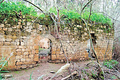
Hundreds of agricultural structures that once served a magnificent and successful network of irrigation in the Palestinian village of Ein Kerem can still be found around Ein Kerem, now a Jerusalem neighborhood. On the hills of Beit Nataf adjacent to Beit Shemesh, an area which the Israel Nature and National Parks Protection Authority (INNPA) wants to turn into a national park, the orchards of the Palestinian village that once stood there continue to shape the landscape.
Historians who are very critical of the Zionist movement, such as Dr. Ilan Pappe, claim that disregarding the existence of Palestinian villages is part of a deliberate effort to erase their history in favor of creating a new one that suits the Zionist narrative of a country that was barren, and only flourished thanks to groups like the JNF. In a study he published, Pappe analyzes the information that JNF provides on several sites, including the Biria Forest, the Jerusalem Forest, the area of Ramat Menashe and the Sataf site near Jerusalem. "The Palestinian orchards are presented as a product of nature, and the history of Palestine is relocated to the period of the Bible and the Talmud", he writes in his discussion of the site of the village of Ein Zeitun in the Biria Forest.
Pappe also points out that the JNF publishes information about unique sites in the Jerusalem Forest and Sataf that testify to the extensive agricultural activity in the region. The information emphasizes the presence of terraces, describing them as ancient, even if they were built and maintained by Palestinian villages.
A recent study conducted by Noga Kadman (as part of her studies in the Department of Peace and Development Research at Goteborg University in Sweden, under the tutelage of Prof. Oren Yiftachel of Ben-Gurion University of the Negev), found about 86 Palestinian villages inside the JNF forests - sites she describes as "emptied". Most of the sites have directional signs, but only 15 percent of them mention the villages by their Arab name. Most of the pamphlets and brochures do not even mention the villages. And in half of the literature where the villages are mentioned, the fact that their inhabitants were Arabs is elided. Only in one case did it say how many people lived in the village, and only in isolated instances is there any discussion of the lives of the inhabitants.
"In most cases, the fact that the villages ceased to exist is not specifically mentioned", writes Kadman. "This can be concluded from the text regarding most of the villages, which are called 'abandoned', and are described as ruins or remains, or mentioned in the past tense."
Bronstein has already submitted Kadman's list of villages to the JNF. He also intends to approach INNPA and ask that it, too, mention the location of abandoned villages in nature reserves and national parks. The INNPA said in response that no site is given preference or ignored because of national or religious affiliation, and that there are several Palestinian villages that are mentioned in signs and in the informational material prepared by the authority.
Yehuda Ziv, who heads the Government Names Committee's subcommittee for community names, and is considered one of the leading experts in Israel in the field, supports the idea of marking the location of abandoned Arab villages.
"I support the mention of the Arab names of various sites, including villages, streams and other places, and I think that they should not have been erased from the map", says Ziv. "One reason is that these names often teach us about the country's Jewish past. There is an additional reason, and that is the fact that these names teach us the history of the country and its landscape. I claimed that original Arab names of existing communities should be added as part of a first map of in Arabic being prepared by the Israel Mapping Center, but I was told that there is no room for that. However, regarding destroyed villages, I think that we should make do simply with a mention of the name of the village."
Join our efforts to expose the truth
Join UsRelated Keywords
Resist the ongoing Nakba
Help us resist the ongoing Nakba
Donate Now
Join our efforts in exposing the truth about the ongoing Nakba and in promoting acknowledgement and responsibility for the injustices of the Nakba, support for the right of return and a commitment to building a just society for all in Palestine.