This unit deals with places that are meaningful to the students. We’ll examine what portion of the history of those places is familiar, which isn’t, and what is the connection between the map and what we see around us. Finally, we’ll introduce the concept of the “Nakba.”
Keywords: Place, Education
Goals
-- Encouraging students to critically analyze the concept of “map.”
-- Arousing their curiosity and encouraging them to ask questions about the history of the place they come from.
-- Allowing the students to get to know each other better.
-- Getting them interested in what happened before, and during, 1948, so they’ll want to know more.
Activity
1. Draw a personal map: Each student will draw a map of the country and indicate on it three places that are meaningful for him (for example, places they particularly like, or are scary, or that they miss, etc.).
To the teacher: If some of the students don’t remember how to draw the map, encourage them to get help from the others.
2. Presenting the results: The students will present their maps, and the places they chose, to the class.
To the teacher: If the class is large, students can present their maps in small groups. The subsequent discussion can be held with the entire class.
3. Class discussion:
-- Why did you choose those places?
-- Do the places you chose have anything in common?
-- Do all the maps have anything in common?
-- You were told at the beginning to “draw a map of the country.” How did you know what map to draw? Would you have drawn a different map had you been told to draw a map of the “State of Israel”? How about the “Land of Israel”? What’s the significance of using different words to describe this place?
4. Suggestion for a follow-up activity:
-- Would your map have looked differently had it been drawn by someone who came from somewhere else?
-- What meaning does a map have for us?
-- We think of a map as being an objective reflection of reality. What do you think about that?
To the teacher: You can draw from the supplementary readings about how maps are used to enrich the class discussion.
5. Summary questions:
-- What do you know about the history of the places you chose?
-- Does anyone know what was located in the places they chose before 1948?
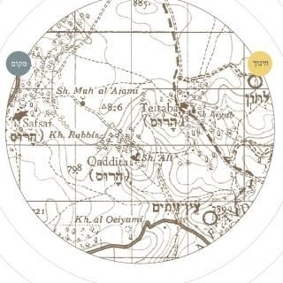
-- The teacher will show the map in Supplementary Material 1 (an Israeli map from the 1950’s showing Palestinian localities that were destroyed), and ask: Guess when this map was drawn? What’s special about it? What does it show? What’s missing? Is it different from other maps of the country that you’re familiar with? The map shows how the country changed dramatically after 1948.
6. The teacher summarizes: Many Palestinian localities existing before 1948 were destroyed and their residents expelled. The maps we’re familiar with today don’t show these localities, which is one of the reasons that we usually don’t know the recent history of where we live – it's Palestinian history before 1948. One of the central issues in our history is what happened here in 1948. We, Israeli Jews, call the events of 1948 “the war of independence,” while the Palestinians call it the Nakba.
-- Have you ever heard about the Nakba?
-- Do you know what the Nakba is?
-- What do you know about it?
7. What does “Nakba” mean: “Nakba” (نكبة) is an Arabic word that means “disaster”, or “catastrophe.” It refers to the destruction in 1948 of most of the Palestinian localities in the territory where Israel was established, making refugees of those who lived there and destroying Palestinian life and culture. Although the Nakba is usually presented as a Palestinian story, it’s in fact our story as well: the Nakba is a part of us even if we’re unfamiliar with it. We’ll learn about that history in the following lessons.
Supplementary material 1
A Segment from a map published by the Survey Department of the Ministry of Labor in 1959, based on a 1942 British map. The map shows the Palestinian localities that existed in the country before the Nakba (their names appear in English). The Hebrew word “destroyed” is printed in purple letters next to the localities that were demolished; new Jewish localities that were established prior to the updating of the map are shown as well. Another example of this map is included in the Supplementary Material to Unit 3.
Theoretical background
A map is an attempt to represent reality. It’s a tool for imagining the landscape. A map is usually considered to be a reliable, accurate portrait of reality, an objective representation of the space it delineates. But a map, in fact, is the product of a particular time and place, of an implicit process of negotiation - an interpretation drawn by the mapmaker. The map shows locations and events according to the political and cultural conceptions of its creators.
Some of the maps we use don’t represent only the physical space, but they are also mental maps. A mental map is personal or collective in nature; it defines the place in which we live, allows us to identify it and assign meaning to its present and past, and includes elements of culture, language, identity, etc.
This unit is designed to increase awareness of what has been erased from the map of Israel. Examining our mental and physical maps draws our attention to the context in which they were created - to their components and the relationships among them. For example, an analysis of some familiar maps of Israel exposes, in fact, the country’s Palestinian history, despite attempts to conceal it.
Pedagogical rationale
The first unit of the Study Guide begins at a location that the students are familiar with, one that is near to them, the place they choose to start talking about themselves. It’s important to note that, while the purpose of this unit is to begin learning about the Nakba, it is also a means for the students to get to know each other. The Nakba is referred to only at the end of the activity, in order to connect it to the activities which follow. This approach, we believe, is sensitive to the range of feelings that the topic is likely to arouse.
The surroundings in which we grew up are imprinted in us as part of our identity and our mental map. The activity begins with the students indicating on the map what they themselves are familiar with – our surroundings. The students are asked to draw a map of the country and indicate on it places which are meaningful to them (for example, places linked to their own biography, places they love, or hate, or miss, and so on). Reacquainting themselves, this time more deeply, with the familiar map is an “easy” way of introducing this difficult topic. At the same time, specifying what we know also specifies what is missing from this portrait of the surroundings - what we don’t know.
This is the unit that introduces learning about the Nakba, but it also includes an activity through which the students get to know one another by learning each other’s biography. By comparing their personal maps, the students will discover how the same map can be drawn in many different ways.
In presenting this activity to the students, we suggest that the teacher refer to the map of “the country.” This term is not specific, intentionally open to many possible interpretations. The language we use to describe the geographical location in which we live includes political expressions that indicate our attitude toward our surroundings and its borders (“Land of Israel,” “State of Israel,” etc.), and therefore our disagreements over what, exactly, the country is, what are its borders, and how the map should look. If students ask which map they should draw, what should be its borders, they should be told to draw a map of the country as they understand it. These issues, and the difficulty of addressing them, should be addressed in the subsequent class discussion.
The maps the students draw, and the locations they indicate on them, will link their personal space, their homes, to the public space, what everyone knows. The discussion at the end of the unit is intended to link the students’ personal relationship to the place (memories, stories, knowledge), to its unreported Palestinian history, the events that occurred there before, and during, 1948. It is important, at the end of this unit, to raise questions in class about which history we know, and which we don’t. It’s also possible to expand the discussion to address how maps are drawn, by whom, who’s on the map and who isn’t, and whether a map is necessarily an objective representation of reality. The goal is to arouse the students’ curiosity so they’ll want to learn more about the Nakba.
Suggestions for further readings
Benvenisti, M. (2000), Sacred Landscape, California: University of California Press.
ברגר, ת. (2008), ברווח בין עולם לצעצוע – על המודל בתרבות הישראלית, תל-אביב: רסלינג (בקשר ליחידה זו, מומלץ הפרק "איך עושים דברים עם מפה", עמ' 62-47). Our translation
English version: Berger, A. (2008), In the Space between the World and the Toy - On the model in Israeli Culture, Tel Aviv: Riesling.
Download File