Info
District: al-Quds (Jerusalem)
Population 1948: 630
Occupation date: 21/10/1948
Occupying unit: Har'el (palmah) & Ezioni
Jewish settlements on village/town land before 1948: None
Jewish settlements on village/town land after 1948: Nes Harim, Bar Giora
Background:
The village stood on a high mountain, overlooking some lower mountain peaks below. Its land extended southwest as far as Wadi al-Maghara. Several springs around the village provided drinking and irrigation water. A secondary road linked Bayt ‘Itab to the Bayt Jibrin-Bethlehem road that ran about 3 km to the south.
Bayt ’Itab is identified with Enadab, which appears in the list of Palestinian towns that was compiled by the fourth century historian Eusebius. The Crusaders knew is at Bethahatap. Edward Robinson visited the village in 1838 and described its stone houses as solidly built. Several houses had two storeys, and in the center of the village were ruins of a Crusader castle. He estimated the village population at six to seven hundred people.
In the 1850s Bayt ‘Itab was the home village of the powerful Lahham family and its rival, the Abu Ghawsh family, in 1855, and Bayt ’Itab was the scene of fierce battles. Afterward, as the regular Ottoman administration penetrated the area, the influence of both families was reduced and Bayt ‘Itab became an ordinary village.
In the late nineteenth century, Bayt ‘Itab was a village built of stone, perched on a rocky knoll that rose 60 to 100 feet above the surrounding hilly ridge. Its population in 1875 was approximately 700. The villagers, who were Muslim, cultivated olive trees on terraces to the north. A large cavern - eighteen feet wide and six feet high - ran beneath the houses. The original layout of the village was circular, but new construction to the southwest gave it the shape of an arc. Most of its houses were built of stone.
Agriculture was the main source of livelihood. The village lands were planted in grain, grapes, olive trees, and other fruit trees. In addition, the residents owned extensive areas on the coastal plain that also were planted in grain. During the Mandate, some village lands were expropriated to make a large, government-owned woodland. The villagers also engaged in livestock breeding. Crops were rainfed and irrigated from springs. In 1944/45 a total of 1,400 dunums was allocated to cereals; 665 dunums were irrigated or used for orchards, of which 116 dunums were planted with olive trees. The village contained the ruins of an old Crusader fortress.
Occupation and Depopulation
Bayt ‘Itab was one of a string of villages in the Jerusalem corridor that was captured following the second truce of the war. Israeli historian Benny Morris writes that it was occupied on 21 October 1948, during Operation ha-Har. The operation was complementary to Operation Yo’av, a simultaneous offensive on the southern front that aimed at thrusting southwards into the Negev.
Israeli Settlements on Village Lands
Israel established the settlement of Nes Harim north of the village site in 1950.
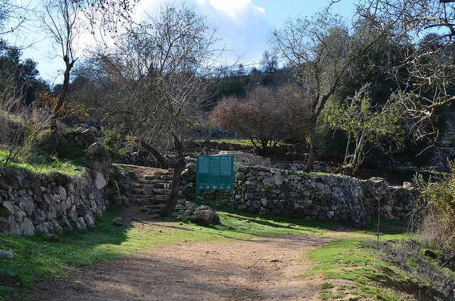
The Village Today
The site is covered with large amounts of rubble from the demolished village houses. The remains of the Crusader fortress are prominent on it. There are two cemeteries east and west of the village. Some of the graves are open, and human bones are visible. Almond, carob, and olive trees grow on the village site and on the lower approaches. Cactuses grow on the southern edge of the site. Part of the surrounding agricultural land is cultivated by Israeli farmers.
---------------------
Source: al-Khalidi, Walid (ed.). All that remains: the Palestinian villages occupied and depopulated by Israel in 1948. Washington DC: 1992.
Images
Videos
Short Documentary by Alex Safron
Booklets
Others
Publications