Info
District: Haifa
Population 1948: 220
Jewish settlements on village/town land before 1948: None
Jewish settlements on village/town land after 1948: None
Background:
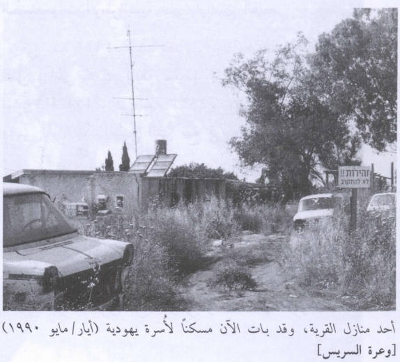
Wa'arat al-Sarris Before 1948
At 11 km distance from Haifa, the village was located on the top of a small hill facing Mount Carmel to the west and southwest, close to a highway that led to Haifa.
Occupation, Depopulation, and Israeli Settlements
At midnight on 3 February 1948, Zionist forces attempting to infiltrate the neighbouring village of Iksal were stopped near Wa'arat al-Sarris after an engagement lasting for over an hour. The Palestinian newspaper Filastin provides an account of the battle but does not give any casualty figures. The newspaper states that the attack was the second to be directed against Iksal (still inhabited by Palestinians today) after fighting had erupted in late 1947.
Because Wa'arat al-Sarris was located close to the villages of Hawsha and Khirbat al-Kasayir, it may have been occupied or evacuated as a result of the attack on those two villages on 16 April 1948. But if residents remained after the attack, they probably panicked after the fall of Haifa a week later, on 22 April, and in the face of the Haganah's subsequent push to occupy the vicinity.
The original village landholdings have been combined with the lands belonging to the Arab town of Shafa 'Amr. The settlement of Qiryat Atta, founded in 1925, has expanded so that some of its buildings occupy the village site.
The Village Today
The neighbourhood of Amidar Aleph, a part of the Jewish settlement of Qiryat Atta, occupies the site. Four partly demolished houses remain; six others are being used by Jewish families. Oak, cypress, and fig trees as well as cactuses grow on the site.
----------------------
Source: al-Khalidi, Walid (ed.). All that remains: the Palestinian villages occupied and depopulated by Israel in 1948. Washington DC: 1992.
Images