Info
District: Safed
Population 1948: 300
Occupation date: 09/06/1967
Jewish settlements on village/town land before 1948: None
Jewish settlements on village/town land after 1948: Snir
Background:
Khan al-Duwayr Before 1948
The village was located on the northeast margin of the al-Hula Plain and overlooked it towards the south. A secondary road passed immediately to the northwest of it and linked Khan al-Duwayr to the town of Banyas in Syria, to a number of villages (including al-Khalisa), and to a highway that led to Safad. It had always been an important stop for the commercial caravans journeying between Syria, Palestine, and Lebanon. An archaeological site known as Tall al-Qadi lay about 1 km to the northwest. This may have been the biblical Laish, referred to in the Old Testament (Judges 1&29) as a walled town conquered by the tribe of Dan in the twelfth century B.C.
In the late nineteenth century, Khan al-Duwayr consisted merely of two stone houses in which twenty people lived. Situated on the slope of a hill, the dwellings were surrounded by olive trees and cultivated land. During the Mandate it was classified as a hamlet in the Palestine Index Gazetteer. Its houses were made of black basalt and mud. In 1944/45 a total of 96 dunums was allocated to cereals; 2,067 dunums were irrigated or used for orchards.
Occupation and Depopulation
Located in the northern tip of the Galilee panhandle, Khan al-Duwayr may not have been entered by Zionist forces until the end of Operation Yiftach (see Abil al-Qamh, Safad District) in late May 1948. But it is more likely that the village came under attack well before then, as the Haganah pushed to control the northern border before the end of the British Mandate on 15 May. Furthermore, the village was accessible from the Jewish settlement of Dafna, which was one of the launching pads for forays into Syria undertaken by Zionist forces during this period. Thus, it may have been targeted in the early stages of Yiftach, in the second half of April.
Israeli Settlements on Village Lands
There are no Israeli settlements on the village land. However, the settlements of Dafna and Dan, both established in 1939, are close to the village site; the former is about 3 km southwest of it, while the latter is 2 km to the west.
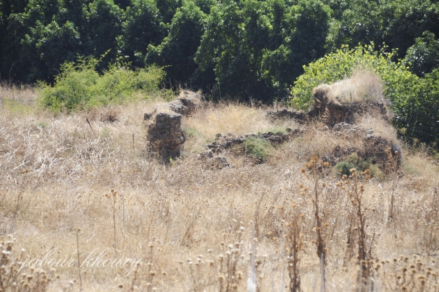
The Village Today
The site is deserted, overgrown with grass. Only the ruinsof a khan (caravansary) are visible. The surrounding land is either cultivated by Israelis, or used as forest or pasture.
-------------------------
Source: al-Khalidi, Walid (ed.). All that remains: the Palestinian villages occupied and depopulated by Israel in 1948. Washington DC: 1992.
Images