Info
District: al-Quds (Jerusalem)
Population 1948: 330
Occupation date: 18/07/1948
Occupying unit: Har'el (palmah)
Jewish settlements on village/town land before 1948: None
Jewish settlements on village/town land after 1948: Kisalon, A part of Ramat Raziel
Background:
Kasla Before 1948
The village stood on the top of an elongated mountain that stretched from east to west, overlooking two deep wadis on the northern and southern sides. The village itself was north of a secondary road that ran across the mountain in an east-west direction. The road intersected a highway to the east, on the outskirts of Jerusalem, and crossed another highway to the west that ran between Bayt Jibrin and the Jerusalem-Jaffa highway. Kasla has been identified with the site of the Canaanite city of Chesalon. It was a large village known as Chesalon nor Cheslon in the Roman period. In 1596 Kasla (or Kisla) was a village in the nahiya of Ramla with a population of sixty-one. It paid taxes on Wheat, barley, sesame, and fruit trees as well as on goats and beehives.
In the late nineteenth century, Kasla was described as a village on top of a rugged ridge with a deep valley to the north. Two springs in the valley and another to the east provided the villagers with water. The village plan was rectangular in shape. Most of its hosues, which were built of stone, extended in an east-west direction along the secondary road; a few houses were built east of the village center along this road. The people of Kasla were Muslim; they maintained a shrine for Shaykh Ahmad. Water for domestic use came from several springs around the village.
Agriculture was based on olives, fruit, and grain, which were planted in the lowlands and valley floors; crops were rainfed and irrigated from springs. Some lands were used as grazing areas, especially in the steep rugged slopes. In 1944/45 a total of 2,265 dunums was allotted to cereals; 440 dunums were irrigated or used for orchards, of which 203 dunums were devoted to olive cultivation. The village was itself an archaeological site and was surrounded by several khirbas that contained the ruins of walls, cisterns, and carved stones.
Occupation and Depopulation
Like nearby Ishwa’ and a few other villages on a side road leading to Jerusalem, Kasla was “cleansed“ on 16 July 1948, according to the History of the War of Independence. Israeli historian Benny Morris puts the date of occupation a day later, on 17-18 July. Morris writes that the villagers in this area either had left earlier, had fled under mortar barrages, or had been expelled by the occupying unit, the Har’el Brigade. The village was overrun as part of Operation Dani.
Israeli Settlements on Village Lands
Israel established the settlement of Ramat Razi’el on village land in 1948. Kesalon was built on village land in 1952, 1 km south of the village site, on the archaeological site of Khirbat Sar’a
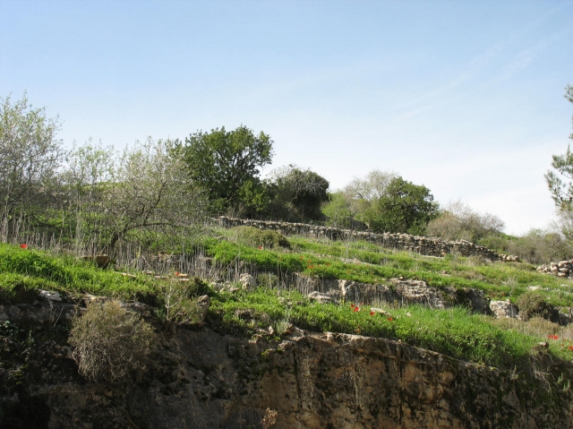
The Village Today
Wild grass covers the entire site and grows amid the rubble of the stone houses, which is difficult to distinguish from the rubble of ruined terraces. Almond trees grow on top of the mountain and cactuses grow along the site’s southern slopes. Northeast of the village, two carob trees are surrounded by the remains of a vineyards. On the slopes, thick wild grass grows on several terraces, which are still intact.
-------------
Source: al-Khalidi, Walid (ed.). All that remains: the Palestinian villages occupied and depopulated by Israel in 1948. Washington DC: 1992.
Images
Videos
Booklets
Others
Publications