Info
District: Tiberias
Population 1948: 560
Occupation date: 12/05/1948
Jewish settlements on village/town land before 1948: Kfar Kish
Jewish settlements on village/town land after 1948: None
Background:
Ma’dhar before 1948
Ma’dhar was a village located 12,5km from the city of Tiberias. It was placed on an elevated, flat terrain in eastern lower Galilee, 6km east of Mount Tabor. It was linked to Kafr Kama by a dirt path in the northwest, and was on a highway leading to Samakh on the southern tip of lake Tiberias.
During the Crusader period, the village was known as Kapharmater, where the Crusader fortress, Casel de Cherio was built. Ma’dhar was built on the remains of the Crusader and Ottoman villages. Ruins from these periods included a ruined church and its burial ground. Khirbat Sara was also an arhaeological site, located to the west.
In 1944-45, the village consisted of 480 inhabitants, all of which were Muslim who maintained a village mosque. During the Ottoman period, a school was constructed, however closed down during the British mandate. The village had no particular shape as such, its houses were placed dispersed and made of stone, adobe and cement with roofs of wood or reeds and covered with mud.
The villagers relied on agriculture and cattle breeding for their livelihood. Agriculture was based on grain and vegetables as well as fruit trees. In 1944-45 there were 5,479 dunums allocated to cereals, 498 dunums were used for orchards or irrigated and 30 dunums were planted with olive trees.
Occupation and depopulation
Regarding the accounts of the depopulation, there are some inconsistencies in the Israeli accounts. Israeli historian, Benny Morris, writes that Ma’dhar was ordered to be evacuated on the 6th of April 1948 by the Arab Higher Committee - which however is deemed unlikely. The History of the Haganah states that it was overrun by units of the Golani brigade on the 12th of May in an operation designed to consolidate control of the Baysan Valley, further stating that the villagers fled in fear. To this day, it is unclear what happened to the villagers after fleeing (or the expulsion) and their houses.
Israeli Settlements on village lands
In 1946, the settlement Kefar Qish was constructed on the village lands on the southern site. In 1938, Sharona was constructed in the nearby area in the north and Shadmot Devora in 1939 in the west. These two are not located on village lands.
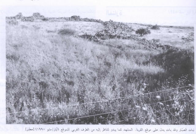
The village today
Today, the village site has been fenced in and is used for Israeli grazing area. In the midst of the stone and rubble houses, large clusters of cacti grow. There is also a well with a capped pump in the center and a drinking trough for animals. Doum palm, eucalyptus and chinaberry trees grow on the site.
------------------------------
Source: al-Khalidi, Walid (ed.). All that remains: the Palestinian villages occupied and depopulated by Israel in 1948. Washington DC: 1992.
Images