Info
District: Gaza
Population 1948: 670
Occupation date: 17/08/1948
Occupying unit: Negev (Palmah)
Jewish settlements on village/town land before 1948: None
Jewish settlements on village/town land after 1948: Yachini
Background:
The village was located in an area of low hills 14.5 km. East of Gaza. Many archeological remains were found on the site including mosaic floors, water holes and pieces of pottery and marble. There is evidence that the place began to be inhabited in the byzantine period. During the reign of the Mamluks (1250-1517) the surplus agricultural produce of the village were donated to the Waqf supporting the dome of the rock in Jerusalem and a mosque in Gaza.
Ottoman documents indicate that 457 people lived in the village in 1596. The place was apparently abandoned during the 17-th and 18-th century since travelers to the region failed to mention it during this period. It reappears on the records in the late 1870-ties. 422 people' lived in the village in 1931. in 86 houses most of which were built with mud and straw bricks. In 1944-5 there were 580 people in the village, all of them Muslim. The village had a mosque and several small shops. A school was built in 1945 and 60 pupils attended.
The village possessed 4855 dunums of land used mainly for dryland farming, barley being the main crop. In the last years of the British mandate figs, almonds and grapes were also planted
Water for household use was primarily obtained from a slightly salty deep well, but was supplemented with rainwater which collected in some shallow domestic wells.
The village with Kawfakha was raided by the Negev Brigade in late May 1948 together with Kawfakha. Israeli historian Benny Morris claims that most of al-Muharraqa's inhabitants were driven out at that time, but it was not thoroughly destroyed and depopulated until August 16
The settlement (moshav) Yakhini was built north of the village site in 1950,According to Morris the moshav T'kuma was established in 1949 on village lands, but it is actually located 2km to the West of the village on lands belonging to the city of Gaza.
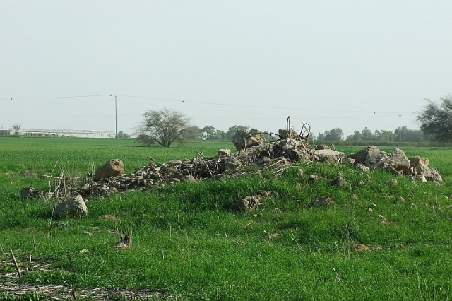
The site is overgrown with thorny plants and short grasses and surrounded by eucalyptus trees. It is marked by piles of rubble from buildings, including the village diwan (a meeting and guest house). There are also the remnants of a mill and a well. The cemetery, overgrown with wild vegetation, still exists, in a dilapidated condition, and the fallen superstructure of one of the tombs is visible. The lands in the vicinity are cultivated by Israeli farmers.
According to Andy Yehezkel almost all the land of the village was government property which had been bequeathed to the Turkish Sultan (Jiftlik lands) and leased to the villagers for yearly payments. The inhabitants originally from Gaza were encouraged by the Ottoman authorities to settle in the village.
After the initial conquest in May 1948 the Israeli army left the village and inhabitants started slowly to return. In August the army prepared to reconquer the village. Intelligence information reported 30 armed men in the village. The Operation Order included “Conquering al-Muharraqa and Kawfakha, driving the inhabitants out, destroying the mill and the Sheikh’s house and mining the villages” In the night of August 16-17 (1948) units of the Negev brigade attacked the villages with machine gun and mortar fire, followed by an infantry invasion accompanied by two armored vehicles. The village surrendered almost without resistance. Three Arab fighters were killed the remainder fled. Those who didn’t were driven out. The mill was destroyed the entrance to the village mined and several houses set on fire. In September 1948 the 3-d battalion of the Yiftah Brigade was ordered to terminate the return of villagers once and for all. On September 22 the battalion raided the two villages arrested four people and blew up houses. Several elderly men were allowed to stay.
Moshav Yakhini which was built on the site of the village was initially named Muharraqa B.
According to the Mapa Encyclopedia the piles of rubble can still be seen on a sown riverbank south of Moshav Yakhini. Moshav Yoshivia which was also built on lands of the village was initially named Muharraqa A, wheras Moshav Yakhini was named Muharraqa B.
Images