Info
District: Haifa
Population 1948: 1970
Occupation date: 12/05/1948
Jewish settlements on village/town land before 1948: None
Jewish settlements on village/town land after 1948: Amikam, Ramot Menashe
Background:
Sabbarin Before 1948
At a distance of 28 km from Haifa, the village was situated on the banks of Wadi al-Tin, which cut through the village in a north-south direction. Secondary roads linked it to the Haifa-Jinin highway and the coastal highway. The Crusaders called it Sabbarim or Sabarim. In the late nineteenth century, the village of Sabbarin was situated on a slope and was built of stone and mud. A large masonry well was located near the village. In modern times, its population consisted of 1,670 Muslims and 30 Christians. The village had a boys' elementary school, as well as numerous wadis and springs which provided water. The villagers were engaged primarily in agriculture and animal husbandry, growing grain, vegetables, and olives. A large masonry shaft west of the village, which has been identified as the head of the Caesarea High Level Roman aqueduct, drew water from springs near Sabbarin. Published archeological surveys have provided minimum evidence of the antiquity of the village.
Occupation, Depopulation, and Israeli Settlements
According to historian Ilan Pappe, it was the Irgun paramilitary organization which completed the vengeful attack on the remaining villages in Marj Ibn Amir, while the British Mandate troops were still there: Sabbarin, Sindiyana, Barieka, Khubbeiza and Umm al-Shauf. Some of the people in these villages fled under the heavy mortar fire of the attacking forces, while others waved white flags signaling surrender were instantly exiled. In Sabbarin, the Irgun bandits, angered by the fact that they encountered some armed resistance, as punishment kept the women, old men and children confined for a few days within barbed wire - very much like the cages in which Palestinians today are kept for hours at checkpoints in the West Bank when they fail to present the right permits. Seven young Palestinian men found carrying arms were executed on the spot by Jewish troops, who then expelled the rest of the villagers to Umm al-Fahm, then not yet in Jewish hands.
The settlement of Ramot Menashe, built in 1948, is on village lands, northeast of the site. Israeli settlers established the settlement of 'Ammiqam in 1950, 1 km south of the village site, on village land.
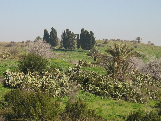
The Village Today
The large site, strewn with the stone debris of houses, is overgrown with wild thorns. The thorns are interspersed with cactuses and pine, fig, olive, and mulberry trees. Some of the surrounding lands are used by Israelis as pasture and for growing fruit trees.
------------------
Sources:
al-Khalidi, Walid (ed.). All that remains: the Palestinian villages occupied and depopulated by Israel in 1948. Washington DC: 1992.
Pappe, Ilan. The Ethnic Cleansing of Palestine. Oxford: 2006.
Images