
Info
District: Safed
Population 1948: 370
Occupation date: 30/10/1948
Jewish settlements on village/town land before 1948: None
Jewish settlements on village/town land after 1948: חלק מברעם
Background:
Fara Before 1948
The village was perched on a relatively high, rocky hill that faced the southeast and overlooked Wadi Fara. Two roads that passed through other neighboring villages connected it to Safad. In 1596, Fara was a village in the nahiya of Jira (liwo’ of Safad) with a population of 281. It paid taxes on a number of crops, including wheat, barley, and olives, as well as on other types of produce and property, such as goats, beehives, vineyards, and a press that was used for processing either olives or grapes. In the late nineteenth century, Fara was situated at the foot of a large hill and had a population of about 100. The houses were built of basalt stones and mud.
The village had a rectangular layout; its longer sides were oriented in a northeast-southwest direction, and its houses were clustered together. It had a cistern on its east side and a pool about 0.25 km to the northeast. All of the residents of Fara were Muslims, and they earned their living primarily from animal husbandry and agriculture. Grain was their most important crop, but they also cultivated fruit trees; their orchards were west and southwest of the village. In 1944 a total of 3,738 dunums was allocated to cereals and 173 dunums were irrigated or used for orchards.
Occupation and Depopulation
The village fell into Israeli hands on 30 October 1948, in the final stage of Operation Hiram (see ‘Arab al-Samniyya, Acre District). Judging from information gathered by Israeli historian Benny Morris, Fara was probably captured by units of the Israeli army’s Sheva’ (Seventh) Brigade as they advanced through upper Galilee from Sa’sa’ to al-Malikiyya, moving eastwards along a road parallel to the Lebanese border. Morris does not indicate what happened to the inhabitants, but if events followed the same pattern as in other villages ii~ the area, they either were expelled or fled out of fear. They were likely to have heard of the nearby massacres committed at the beginning of Operation Hiram; after news of the carnage spread in Upper Galilee, only a few communities remained.
Israeli Settlements on Village Lands
There are no Israeli settlements on village land.
The Village Today
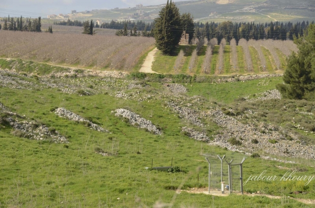
One stone building (probably a mosque) stands on the site, as well as several stone terraces. On the whole, however, the site is overgrown with grass and fig trees. Less than 1 km north of it lies the settlement of Yir’on . A portion of the land around the village is planted with fruit trees, such as apples, but the land along the valley’s slope is deserted and uncultivated.
----------------------------------------
Source: al-Khalidi, Walid (ed.). All that remains: the Palestinian villages occupied and depopulated by Israel in 1948. Washington DC: 1992.
Images
Videos
Booklets
Others
Publications
