Info
District: Safed
Occupation date: 22/04/1948
Occupying unit: Palmah 1st battalion
Jewish settlements on village/town land before 1948: Hulata
Jewish settlements on village/town land after 1948: None
Background:
Tulayl Before 1948
The village was situated on a small, sandy hill on the southwestern shore of Lake al-Hula, near the merging of the a1-Hindaj and Waqqas wadis with the lake. Its hilltop location protected it from floods. Many scholars identify the mound on which Tulayl was built with the Roman town of Thella. In 1596, Tulayl was a village in the nahiya ofJira (liwa’ of Safad) with a population of 215. It paid taxes on a number of crops, including wheat and barley, as well as on other types of produce, such as bees and water buffalo. Its houses, made of mud and cane, were closely packed.
In modem times the village expanded westward, and by the end of the British Mandate, it had approached the village of al-Husayniyya, which itself was expanding eastwards. The two thus became virtually one village with shared services, including a school established by the local Society of Village Improvement. The entire population of the two villages was Muslim. Agriculture was the main source of livelihood; the villagers grew mostly grain and vegetables, although some of them raised water buffalo and others were fishermen. In 1944/ 45 a total of 3,388 dunums was allocated to cereals and 22 dunums were irrigated or used for orchards.
Occupation and Depopulation
Like most villages in the neighborhood of Lake al-Hula, Tulayl was conquered in the course of Operation Yiftach (see Abil al-Qamh, Salad District). Little is recorded about the manner in which this happened, but Israeli historian Benny Morris speculates that its inhabitants abandoned it in late April 1948. Most nearby villages were depopulated as a result of either bombardment by mortars or a psychological warfare campaign designed to instill fear of an imminent attack, or by both. These measures were adopted partly in preparation for the capture of Salad, and partly to achieve the depopulation of eastern Galilee.
Israeli Settlements on Village Lands
In 1883, Zionists had established the fortress settlement of Yesud ha-Ma’ala about 1.5 km northwest of the village site. It was not, however, on village land. The settlement of Chulata , founded in 1937 on village land, is 1 km to the northwest of the village site.
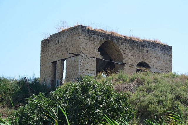
The Village Today
The village site is thickly covered with grass and other vegetation, including some eucalyptus and palm trees. Only one old stone house, with an arched doorway, remains standing. The surrounding land is now cultivated by the settlement of Chulata.
------------------------------
Source: al-Khalidi, Walid (ed.). All that remains: the Palestinian villages occupied and depopulated by Israel in 1948. Washington DC: 1992.
Images