Info
District: al-Quds (Jerusalem)
Population 1948: 510
Occupation date: 22/10/1948
Occupying unit: Har'el (palmah) & Ezioni
Jewish settlements on village/town land before 1948: None
Jewish settlements on village/town land after 1948: Mata
Background:
‘Allar Before 1948
The village stood on the northeastern slope of a mountain range and overlooked a tributary of Wadi al-Sarar that ran parallel to this range. A secondary road connected it to a road that linked Bayt Jibrin to Bethlehem and that ran 1 km south of ‘Allar. In 1596 ‘Allar was a village in the nahiya of al Quds (Jerusalem) with a population of 204. It paid taxes on wheat, barley, olive trees, molasses, goats and beehives. The traveler Edward Robinson saw it in 1838 when he passed through the area. He said it was on a hill, slightly above its sister village, ‘Allar al-Sufla. By 1875 it had a population of approximately 400.
In the late nineteenth century, ‘Allar was built on the slope of a ridge with a well to the south and rock-cut tombs to the north. The village stretched out along an approximately east-west axis. Its houses, built of stone, were connected by narrow, winding streets. Small village shops were built along those streets. The residents of ‘Allar were Muslims and maintained four maqams (shrines) in the vicinity. Their children were educated in the village elementary school.
The villagers relied mainly on agriculture for their livelihood, and cultivated grain, vegetables, olives and grapes. Most of these crops were rainfed, but some were irrigated with water drawn from the several springs around the village, including ‘Ayn al-Tannur. In 1944/45 a total of 2,234 dunums was allocated to cereals; 353 dunums were irrigated or used for orchards. Wild trees and grass also grew on village lands. The village also had several khirbas int is vicinity, including Khirbat al-Shaykh Ibrahim, named after one of the local religious teachers whose tomb had been made into a maqam.
Occupation and Depopulation
According to research conducted by Israeli historian Benny Morris, ‘Allar, captured on 22 October, was one of a string of villages occupied during Operation ha-Har.
Operation ha-Har was an offensive launched by the Israeli army’s Har’el and Etzioni brigades after the second truce. The objective of the operation was to widen the Israeli-held corridor to Jerusalem and link it with territory occupied in the Hebron hills. Israeli forces moved to occupy a number of villages in the southern half of the Jerusalem corridor. The operation was complementary to Operation Yo’av, mounted further south, and both were clearly aimed at getting rid of Palestinian civilian communities in the areas occupied.
The operation began on the night of 18-19 October with an attack on Egyptian forces just west of Dayr Aban. At this location, Israeli and Egyptian forces had been positioned just 60 m apart throughout the second truce, according to the History of the War of Independence. Most of the villages in the vicinity of Dayr Aban were defended by Egyptian units. Although the Israeli forces engaged the Egyptian troops, they took great care not to draw Transjordan’s Arab Legion into the battle in this sector. During Operation ha-Har, the Egyptian arm was forced to retreat to the west, and Israeli forces captured many villages southwest of Jerusalem.
While there is no documentary evidence that Yigal Allon, the commander of the operation, issued expulsion orders to the units that carried out Operation ha-Har, Morris writes that “…it is quite possible that he indicated his wished in pre-battle têtes-à-têtes with his officers.“ The population of this region either was expelled or fled under pressure, probably in the direction of Bethlehem and the Hebron hills. A large number of refugees remained encamped in the gullies and caves around their villages, only to be expelled during Israeli raids in subsequent months.
Israeli Settlements on Village Lands
Israel established the settlement of Matta’ on the southern edge of the village site in 1950. Bar-Giyyora, also founded in 1950, is northeast of the site. Both are on the village lands.
The Village Today
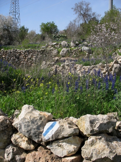
Stone rubble, concrete blocks and slabs, and steel bars litter the site, together with the remains of stone terraces and walls. One domed stone structure, the former school building, still stands. On the slopes overlooking the site, almond and cypress trees and cactuses grow along the terraces.
-------------------
Source: al-Khalidi, Walid (ed.). All that remains: the Palestinian villages occupied and depopulated by Israel in 1948. Washington DC: 1992.
Images