The remains of Dayr Aban are currently located near Moshav Mahseya, east of Beit Shemesh on Road 3855. Mahseya itself has been built over the ruins of Dayr Aban’s al-Battin neighborhood, which included residences, a small cemetery, a saintly grave, a school and a water fountain from the 1930s.
The village center is located south of Mahseya. To get there, turn right about 200 meters after the main entrance to the moshav, and after some 400m turn from the asphalt road to a dirt road on the right. The words Derech Eretz (in Hebrew) on the road sign refer to a wedding parlor which operates among the ruins of the destroyed Palestinian village, and even uses part of a Palestinian building as an intimate chamber for newlyweds. At the start of the dirt road and before reaching the wedding parlor, you will see many piles of stones on the left. These were the village houses.
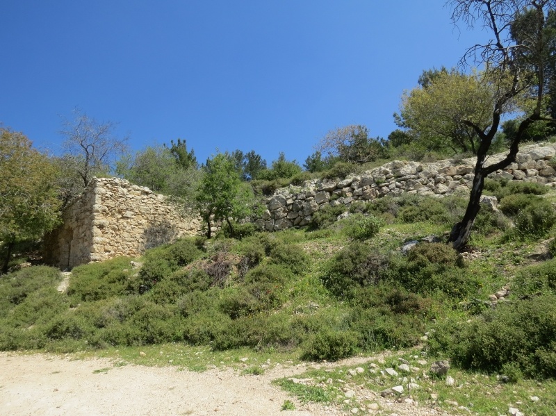
Further down the road you will see a cave next to a ruined house, one wall of which, with the base of an arch on the top, is still standing. This is the home of ‘Abd al-Hafidh ‘Ali Da’amseh’s family. ‘Abd al-Hafidh was shot and killed in the courtyard of his home in 1948 by an Israeli sniper placed on an overlooking hill, where one of Beit Shemesh’s neighborhoods is now located. His family members currently reside at al-Duheisheh refugee Camp in Bethlehem.
After several hundred meters down the dirt road we arrive at the wedding parlor. The road that leads southwards, with the wedding parlor on the right, leads us along a riverbed among ruins and fields to Dayr Aban’s main cemetery – a distance of some 2km. The cemetery is located on a steep hill. Its current condition is shameful, it is neither marked nor fenced, with most graves ransacked and destroyed, and in some cases we can even see the exposed bones of the dead. The cemetery can be identified by an isolated stone structure – the home of Muhammad Sallim Rabba’ – which is located under the cemetery in its northern edge. The road leading to and around the graveyard is an official trail marked with blue-and-white.
(1).JPG)
Behind the wedding parlor we can see the ruins of multiple houses and wells in the neighborhood named Al-Qatti’ by the residents of Dayr Aban. Throughout the villages we can identify its original cacti and trees such as olive, cherub, and almond trees. Today the village area belongs mostly to the Jewish National Fund (JNF) and included in the American Independence Park it created on the ruins of Dayr Aban and other Palestinian villages, such as Jarash, Sufla, Khirbat al-Tannur, ‘Allar, Dayr al-Hawa and Bayt ‘Itab, occupied in 1948 – hence the foreign pine trees dominating the present landscape.
Sixty people, most of whom Israelis, participated in the tour. At the end of the tour, we discussed possible initiatives for renovating the cemetery. In keeping with Zochrot traditions, during the tour we launched the “Remembering Dayr Aban” booklet as well as posted signs at the entrance to the village and cemetery to commemorate its name which Israel has erased from its maps and physical space.
Two weeks after this tour, we held an additional tour of Dayr Aban, this time together with the “Falestiniyyat” NGO from the Galilee. About 70 people, mostly Palestinian youngsters from the north and Jerusalem took part in the tour. During this tour, we symbolically covered some of the open graves in protest against their desecration and called for concrete steps to ensure their future preservation.
For more info about Daye Aban please see Zochrot's booklet: Remembering Dayr Aban