Info
District: Gaza
Population 1948: 3190
Occupation date: 10/05/1948
Occupying unit: Giva'ati
Jewish settlements on village/town land before 1948: None
Jewish settlements on village/town land after 1948: Givati, A part of Azrikam
Background:
Bayt Daras before 1948
The village was located 32 km. northeast of Gaza on flat land which slopes upwards to the west and southwest to form a hill. The Crusaders built a castle on the hill and the Mamluks built a Khan (caravansary ) in the village. 319 people lived in the village in 1596. In 1931 the count was 1804 people living in 401 houses. By 1944-45 the number had increased to 2750.. The village had two mosques and an elementary school with 234 pupils in the mid- forties. 16357 dunums of arable land were used to grow citrus ,bananas and cereals, most of it rainfed. Poultry were also raised in the village and some people worked in commerce and handicraft.
Occupation and Depopulation
According to the Arab militia commander in the area the first clashes took place early in the war. Following a skirmish between Arab Militiamen and a Jewish convoy on March 27-th 1948 the village came under heavy mortar fire in the night of 27-28 th of March. The attack left 9 non-combatant villagers dead and caused a fire which burned livestock and crops.
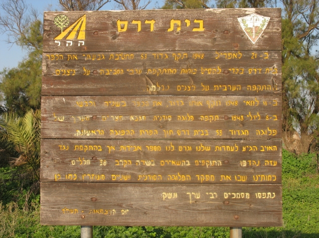
Israeli historian Benny Morris states that the village was occupied by the Giv'ati Brigade in the early stages of operation Barak on May 10-th. The aim of the operation in accordance with Plan Dalet was the cleansing of the southern border of the designated Jewish state before May 15-th. According to Morris the villagers fled during the assault and their houses were blown up.
Egyptian sources report that the village was occupied by Israeli forces only on June 11-th, shortly after the first truce began.
Israeli settlements on village lands
In 1950 three Israeli settlements were established on village lands: Azriqam, Emunim and Giv'ati. A few years later the Zemorot farm was also established on village lands.
The Village Today
The foundations of one house and some rubble are all that remains from the village. The site is overgrown by wild vegetation interspersed by cactuses and eucalyptus trees. One of the streets is still recognizable. The surrounding fields are cultivated by Jewish settlers.
-------------------------------------------
Source: Walid Khalidi: 1992 "All that remains" pp87-88
Information from additional sources:
According to Israeli historian Benny Morris the Arab National Committee tried to prevent the villagers from leaving their homes. At first they were warned not to leave , the guards in Majdal and Gaza were instructed not to let them in and after they fled they were transported back by the Arab Military Command (The Birth of the Palestinian Refugee Problem 1991 p.102)
Salman Abu Sitta, a Palestinian scholar specializing in the Palestinian Refugee problem estimates that 3190 people lived in the village in 1948, (Salman Abu Sitta, The Palestinian Nakba 1948, 2000, 44)
According to Andy Yehezkel only the settlements Giv'ati and part of Azriqam are built on village lands.
Noga Kadman locates the remnants of the village proper within the Nature Reserve "Zemorot Pond" and the nearby JNF site (Noga Kadman "Erased from Space and Consciousness" 2015, Appendix A)
Images